
How Dry is It?
From satellites to boots-on-the-ground, measuring drought in Montana is a team effort
Much of Montana has a semi-arid climate where drought is a cyclical, natural phenomenon. Droughts are common, occurring somewhere in the state in all but two of the last 25 years. Montana’s diverse geography and climatic variability means that droughts are rarely ever alike, differing in location, onset, intensity, and type. Drought conditions can also vary widely in any given year. A low snowpack could leave streams dangerously low in the summer, while a wet winter followed by a hot, dry summer can rapidly deplete soil moisture and damage forests, crops and rangelands. Drought can develop quickly over a matter of weeks or progress slowly over a matter of months or even years. This high level of variability and uncertainty helps explain the old but accurate saying, “In Montana, we are never more than a week away from a drought.”
The U.S. Drought Monitor (droughtmonitor.unl.edu) is a weekly assessment that classifies drought conditions across all 50 states and Puerto Rico. Each week, scientists at the National Drought Mitigation Center at the University of Nebraska in Lincoln use drought indicators and other metrics along with input from state partners to develop a map of drought with five levels of increasing intensity: D0 (abnormally dry), Stage 1 (moderate), Stage 2 (severe), Stage 3 (extreme), and Stage 4 (exceptional). In Montana it is common for conditions to range from normal (no drought) in one part of the state to D4 in another. The accurate depiction of drought classifications is critical since the availability of federal drought relief to agricultural producers is tied directly to the maps developed by the U.S. Drought Monitor.
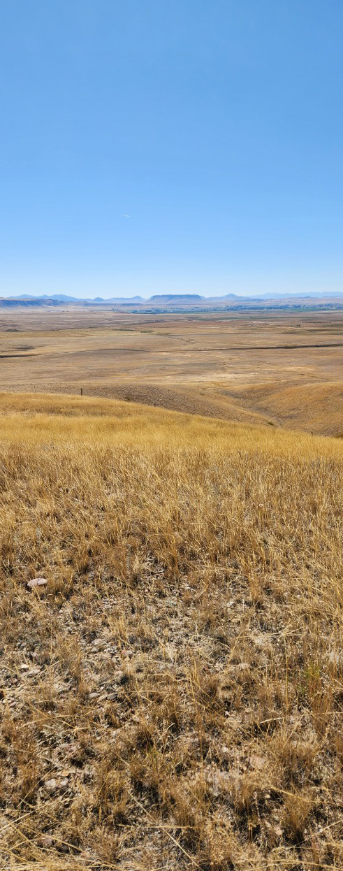
Photo: Mitch Konen
Photo submitted to the Impact Reporter by Mitch Konen. Cascade County between Sun River and Fairfield, 9/18/2023. “Looking south into Sun River drainage from northern rim of valley. Dryland hay production was very good due to early spring rains. But with only about an inch of moisture since the first of June, there has been no recovery moisture adequate enough to support regrowth. Local springs and water holes are diminishing.”
With drought as a regular visitor that can bring devastating consequences, it makes sense that we spend time and resources tracking both its development and recession. This effort requires good indicators to accurately signal drought onset and measure its severity. Much like a weather report, Montana’s weekly drought assessment relies on measurements of precipitation, temperature, snowpack, wind, evaporation, vegetation greenness, and other variables to accurately evaluate the location and stages of drought. These science-based tools are incorporated into the drought indicators dashboard (drought.climate.umt.edu), but unfortunately, these metrics do not perfectly represent actual conditions on the ground. There is no single indicator that can provide an accurate depiction of local drought conditions. As a result, managers rely on multiple indicators and observational inputs as evidence to develop an accurate assessment.
In Montana, each week a team of scientists and resource managers evaluate weather and water information provided by monitoring networks like the Montana Mesonet (a weather and soil moisture station network), streamgages that measure flow rates, SnoTel sites that provide measurements of snowpack, National Weather Service stations, and modeled weather data to calculate drought location and severity. Observations from agricultural producers, water managers, recreationists and others also provide accurate and timely information on local conditions that may fall outside the range of other networks. The combined data from the monitoring network and observational input from local, Tribal, state and federal partners is critical to the accurate depiction of Montana’s drought conditions.
Montana’s size, geographic diversity and climate variability make it difficult to accurately represent the location and severity of drought. For example, in Liberty and Toole Counties in the summer of 2023, information from Montana’s weather monitoring network and associated drought metrics indicated below-average to average precipitation. But reports from agricultural producers indicated severely dry conditions. The disparity in these indicators created a puzzle.

Photo: U.S. Drought Monitor
Screenshot from the U.S. Drought Monitor indicating drought levels in Montana for May 7, 2024.
How could it be so extremely dry when most of the indicators showed only moderate dryness? This area received average to above average rainfall from late May to early June. But from June 10 to August 20 the Shelby Airport received only 0.56 inches of rain, more than 3 inches below normal and a new record low for that period. Upon closer analysis, weather records showed that unusually large rain events in early June and late August masked the extremely dry conditions that lasted for 71 days in the heart of the growing season. Fortunately, producers in the area reached out to Montana’s drought monitoring team with local observations to alert them about conditions in this area and the drought maps were revised.
In recent years, new technology and strategic investments in weather and drought monitoring infrastructure has greatly improved the ability to identify and monitor drought conditions across Montana. Despite those improvements, field scale assessment of drought severity is all but impossible in a state this large and diverse.
In response to this gap, Montana Department of Natural Resources and Conservation and the State Library developed the Montana Drought Impact Reporter. The Impact Reporter is an online tool that enables individuals to submit local observations and upload photographs of conditions in their area. Users can also view other drought impact reports from around the state and the country. This important tool expands the detail of Montana’s drought monitoring network to include insight and data provided directly by local individuals. Impact Reports are reviewed weekly by Montana’s drought monitoring team.
For more information, visit the Montana Drought Impact Reporter at survey123.arcgis.com/share/9256e9943a964af5ad7e0280e1407712.
Michael Downey is the Drought Program Coordinator for the Montana Department of Natural Resources and Conservation.