
The Colt Summit Project: Why Private Forest Landowners Should Collaborate with Neighbors
By Dave Atikns and Tim Love
If you own forest land, whether it is 10 acres or a thousand-plus, you treasure your land for a multitude of reasons. The privacy it provides you and your family, the wildlife habitat, the recreation, the occasional timber harvest for firewood, sawlogs, posts and poles, etc., and many more reasons.
The more you learn about your land and its place in the watershed landscape, the wide-ranging wildlife species, the risk of wildfires, the insects, windstorms, and diseases, the more you learn how interconnected all of these elements of the ecosystem are, and the values you enjoy from them are part of the intricate web of your lives with these systems. You also learn how you can reduce risks on your land. However, what does or does not happen on neighboring lands upstream or downstream influences you and your land. The habitat, the water, the health of the trees, and the risk of undesirable wildfire or insect effects don’t stop at the property line. Therefore, you should be interested in the bigger picture.
The Cambridge Dictionary defines collaboration as the situation of two or more people working together to create or achieve the same thing. The Montana Forest Collaborative Network is a collection of 25 collaborative groups around Montana that work together to achieve the protection and maintenance of forest and rangeland restoration, conservation, and utilization for the benefit of all.
Collaboration can be between two neighbors using the same contractor to harvest, treat wildfire fuels or conduct a planned burn across property boundaries. It may be on 20 or 100 acres to make the whole operation more efficient and effective from both a cost and results perspective. Collaboration can also be on federal, state, and private lands involving multiple organizations and individuals to achieve landscape-level results.
To illustrate how a private landowner can participate in the process we want to tell the story about the Colt Summit collaborative landscape project a little north of Seeley Lake, Montana. We will explore why and how it was developed, who was involved, and what the results have been, culminating with the Colt Wildfire of 2023 that tested the efficacy of the work.
The wildfires in the summer of 2000 led to the passage of the National Fire Plan and provided funding to local communities to develop a “Community Wildfire Protection Plan” or CWPP. The Seeley-Swan area was one of the first rural communities to complete one. They developed their CWPP during 2003 and 2004. It was the result of collaboration between people in both valleys recognizing the need for action around their homes, businesses, and communities, as well as in the forest, to reduce the risk of substantial economic, social, and environmental losses. The plan allowed residents to access grant money to reduce risk around their homes and land. It helped agencies to identify priority treatments on the landscape to improve escape routes and create forests that could sustain a fire resistant to high severity and resilient in their recovery.
About the same time, the Seeley Lake Ranger District was looking to apply the recently developed Montana Restoration Principles, produced through a collaborative process. It involved recreation groups, environmental groups, conservation organizations and wood products industry, local business, and state and federal agency leaders. In 2009, Colt Summit became one of the initial projects to use these principles in conjunction with the Lolo Restoration Committee and the newly formed “Southwest Crown of the Continent” (SWCC) collaborative. The SWCC became active and applied to be one of the pilot projects empowered by the new federal legislation called the “Collaborative Forest Landscape Restoration Program” (CFLRP). It was selected as one of 10 nationwide demonstrations.
Through many meetings, the diverse set of people and organizations designed a combination of activities to achieve an integrated set of goals applying the restoration principles.
These included: enhancing grizzly bear habitat, improving bull trout habitat, planning tree harvests to reduce the forest density, and conducting prescribed broadcast and pile burns to reduce the fine fuels on the ground and in the canopy. The harvest and burns intention was to reduce the intensity and severity of the inevitable wildfire and help implement the new community wildfire protection plan.
Table 1 lists some of the project activities and Figure 1 shows the location of the activities across the landscape. Highway 83 is a major travel corridor with powerline utilities along it and a myriad of homes, businesses, campgrounds, and private land scattered up and down the valley. You can see the treatments were aggregated across the landscape to create large patches of forest where the harvest and burning would provide a break in the fuel continuity and provide suppression crews with a safer location to conduct burnout operations in case of future wildfires. A Decision Notice (DN) and Finding of No Significant Impact (FONSI) by the Forest Service was issued on March 23, 2010, built upon the work of all the participants.
| Activity | Miles | Acres |
| Road decomissioning | 11 | |
| Road re-route out of riparian area | 4.1 | |
| Improvement cut and burn | 1,229 | |
|
Old growth enhancement Understory slashing and burning |
137 | |
| Shelterwood patch cuts | 352 | |
| Understory slashing and under burn | 280 | |
| Vista cuts | 45 |
Table 1.
The reroute of road 646, by converting 4.1 miles of road in the Colt Creek riparian area to a trail, removed a recurring source of sediment which then benefited water quality and habitat for Bull and West Slope Cutthroat Trout. It also made a safer grizzly bear travel and feeding corridor. The treatments within and surrounding the old-growth forests greatly enhance their likelihood of surviving a wildfire. Treatments of noxious weeds help protect native plant communities and habitats.
The various harvests designed to reduce fuel continuity produced about 7 million board feet of timber and left behind forests with enhanced growth potential, resistance, and resilience to insect attack and severe wildfire in the forests, and ultimately will provide harvest opportunities decades into the future. The treatments adjoin private landowners, some of whom have conducted harvests, small tree thinning and slash burning activities on their lands. You can see how the FS treatments occurred around three sides of the private land.
Some groups refused to join the collaborative process. Remember that collaboration means two or more people working to achieve or create the same thing. The groups may not agree that harvests and fuel treatments designed to change wildfire behavior are effective, or agree that the effects can reduce insect risks for a period of time, or that additional treatments would be needed in the future as the forest grows and changes. The groups opposed to the collaboratively developed restoration goals appealed the Forest Service decision and tried to stop it.
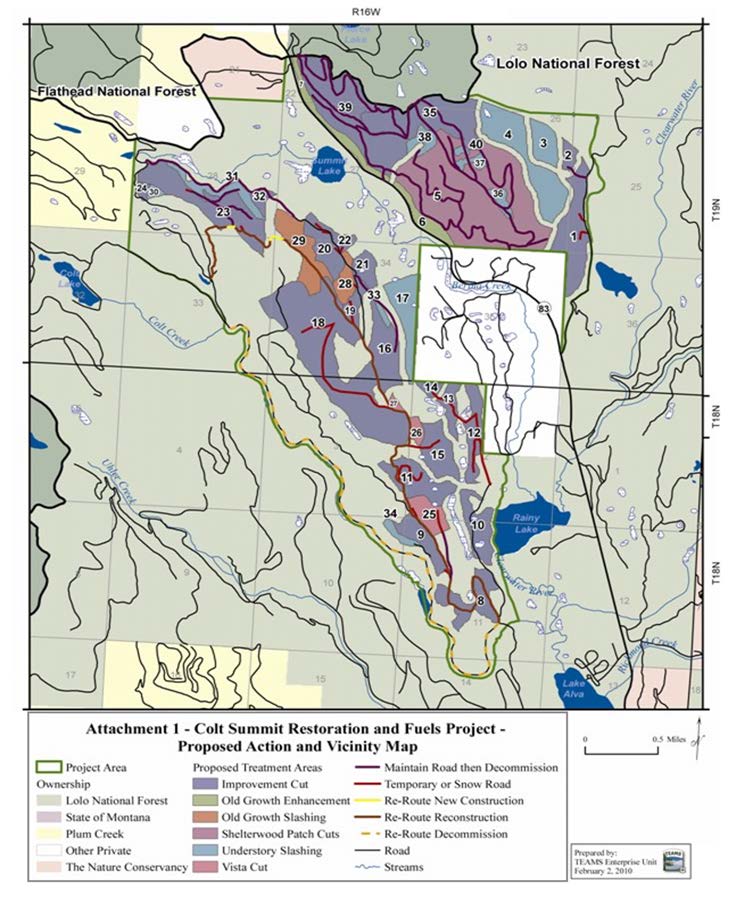
Figure 1. Colt Summit Restoration and Fuels Proposed Actions
The decision was upheld by the Forest Service Regional Office on June 30, 2011, and the opponents of the project filed a lawsuit. They alleged many violations by the US Fish and Wildlife Service and the US Forest Service with the District Judge on September 16, 2011. The judge enjoined the decision, preventing implementation of the project while being adjudicated. The lawsuit motivated 32 agencies, organizations, local governments, and individuals involved in the collaborative process to file amicus briefs with the judge in support of the US Forest Service and US Fish and Wildlife Service between February 27, 2011, and March 6, 2011. On July 20, 2012, the US District Court upheld USFS and USFWS on all issues except one. The judge asked for more documentation of the lynx cumulative effects analysis. The USFS documented an expanded cumulative effects analysis by June of 2013 and then signed a new Decision Notice and Finding of No Significant Impact on January 16, 2013. The additional analysis and documentation resulted in no changes to the original decision issued in March of 2010.
The updated DN and FONSI and updated Administrative Record were provided to US District Court which upheld the new decision and removed the injunction on April 4, 2014, four years after the original decision with the same activities scheduled. The plaintiffs were not satisfied and appealed the District Court’s Decision on May 29, 2014, to the Ninth Circuit Court of Appeals. The Ninth Circuit denied their motion for an injunction of the decision on June 20, 2014. This allowed the Seeley Ranger District to award the contracts to repair and, in some cases, eliminate unneeded roads contributing to sediment in Colt Creek, conduct the harvest and fuels treatments of thinning, piling and burning, and in some cases conduct an under burn. All the fieldwork continued as the Circuit Court reviewed the lower court decision. The review was completed in 2018 and the Ninth Circuit upheld the lower court decision.
We believe the collaborative process and the 32 amicus briefs demonstrated to the court the validity of the decision-making process and thus refused to enjoin the decision during the appeal.
Implementation on the ground between 2014 and 2018 produced results that were crucial to the Incident Command Teams that managed the Colt Fire of 2023. The fire started from lightning on July 17, 2023, and quickly grew beyond the initial attack’s suppression ability. Within 4-5 days an overhead team was called in and the list of priorities for managing the fire was: protecting private property, homes, and infrastructure in the Highway 83 corridor. The potential values at risk to the east included many homes between Rainy and Summit Lakes, but also homes around and near Lindbergh Lake to the north and to the southeast along the east shore of Inez Lake.
The operations team came back to camp after reviewing the fire and potential control lines and were heard to say how great it was to have road 646 with fuel treatment already accomplished and it provided the perfect place to conduct a burnout operation with minimal risk to firefighters or escape from the containment lines.
In Figure 2, you can see the eastern boundary of the fire is along road 646 and the burnout operations conducted over several days was inside the treatment units of Colt Summit. As a result of these advanced treatments and the Incident Management Team’s burnouts, the wildfire never reached private land approximated by the red box.
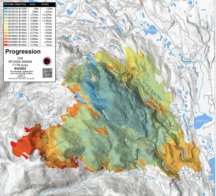
Figure 2. Colt Fire progression map
We arrived at several conclusions from this example of collaborative management.
- Fuel treatments work.
- The fire never reached private property, and powerlines remained intact and serviceable.
- Harvesting reduced the density of trees, avoiding crown fire behavior.
- Broadcast under burning and piling and burning reduced the fire intensity and severity.
-
Collaboratively developed projects can achieve multiple objectives for public and private landowners, including grizzly bears, aquatic species, goshawks, lynx habitat and treating noxious weeds.
-
Collaboratively developed projects are more robust when challenged; having amicus briefs filed was beneficial.
-
Collaboratively developed projects on federal lands are not fast and do not preclude litigation and delays. However, broad public support does seem to influence how the courts handle federal lands litigation.
-
More documentation required by the judge did not change the project and it did not affect the outcome, but it did delay treatments for four years.
-
Individuals are an important member of their landscape and community and their input and perspective is important. Consider joining a collaborative.
Do you want the lands surrounding yours to be resilient and resistant to wildfire, insects, and disease? Do you want to reduce the costs of wildfires or insect epidemics? Do you want greater protection and resilience for your land? If the answer is yes, getting neighbors, whether private individuals, corporate, state, or federal entities, to work together to achieve cross-boundary treatments to achieve landscape-level goals requires collaboration. It is the path forward. It requires patience (listening and learning from each other), persistence (it doesn’t happen fast), participation (you must show up), and perseverance (democracy is messy but it is vital).